13 November, 2023
Monitoring as a Service: Unlocking the Potential of Satellite Imagery
In a rapidly changing world heavily driven by data, the utilisation of satellite imagery has emerged as a leading solution for addressing a wide range of global concerns. From overseeing mining operations and environmental monitoring to disaster management and agriculture, satellite technologies have become a contemporary solution for governments, businesses, and researchers alike.
To harness the full potential of this vast and dynamic field, there is a need for a paradigm shift towards more efficient, scalable, and accessible solutions. This is where Monitoring as a Service (MaaS) steps in as a transformative concept. MaaS represents a compelling approach to leveraging the capabilities of satellite imagery and geospatial data, making these resources more readily available and user-friendly. It enables access to crucial insights, allowing stakeholders from various industries to make informed decisions quickly and accurately.
What is MaaS?
MaaS is a specialised service offered by Geoimage that harnesses the power of satellite imagery and geospatial solutions to monitor and provide invaluable insights into various aspects of the Earth's surface. Here's a brief overview of what Geoimage's MaaS solutions encompass:
- Satellite Imagery: Our MaaS solutions rely on data collected from satellites, sourced through our trusted partners, including Maxar, Airbus, and RESTEC to name a few. As an independent operator, we have the flexibility to choose the most suitable solution that aligns with your specific requirements.
- Continuous Monitoring: MaaS offers continuous monitoring of specific areas of interest (AOI). For example, it can track changes in land use, deforestation, urban expansion, crop health, stockpile monitoring, and more. This ongoing monitoring empowers organisations and governments to make informed decisions and respond to changes as required.
- Data Analysis and Interpretation: The satellite imagery undergoes processing and analysis using geospatial techniques to derive actionable insights. Our algorithms can be employed to detect anomalies, trends, and patterns in the data. This analysis can be automated and seamlessly integrated into decision-making processes.
- Visualisation and Reporting: The results of our monitoring solutions can be presented through a user-friendly interface, such as our web-based platform, groundWATCH. This allows users to easily comprehend the data and its implications to then make informed decisions.
- Access to Historical Data: Many of our trusted partners maintain historical archives of their satellite imagery, which can be invaluable for trend analysis, impact assessment, and long-term planning.
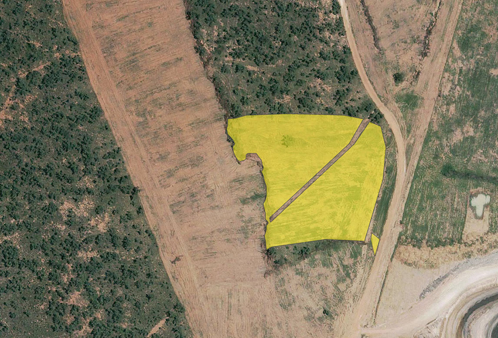
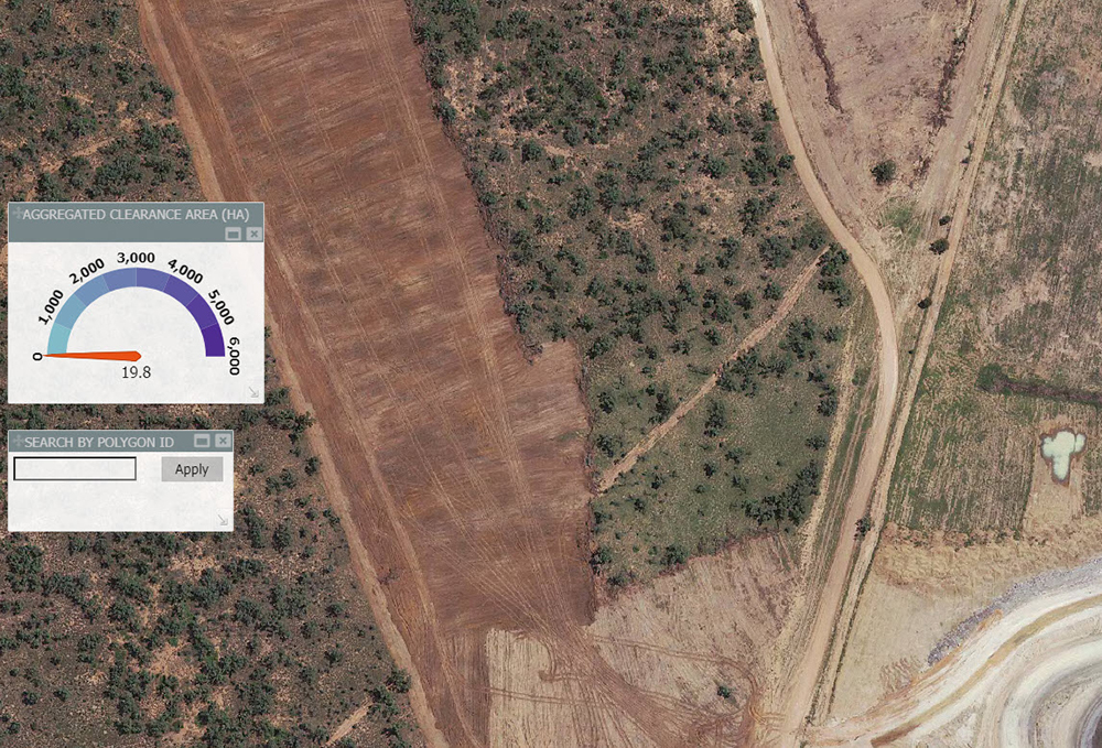
Below: Before and after sample of change detection with a vector overlay.
The Benefits of MaaS
The implementation of MaaS is accompanied by an abundance of benefits that extend across various industries:
- Cost Efficiency: MaaS reduces the need for costly field surveys and site visits, offering a more cost-effective and timely solution for data acquisition.
- Data Accuracy: Satellite imagery provides highly accurate and up-to-date information, allowing for better decision-making.
- Environmental Conservation: By monitoring environmental changes, MaaS contributes to the preservation of ecosystems and the sustainable use of natural resources.
- Improved Disaster Preparedness: Timely information from MaaS can help with disaster preparation and response, potentially saving lives and decreasing damage.
- Enhanced Urban Planning: Sustainable urban development and infrastructure planning are made easier with access to detailed geospatial data.
- Agricultural Productivity: MaaS enhances crop monitoring, contributing to increased agricultural productivity and efficient resource management.
- Increased Safety: By eliminating the need for personnel to be physically present in potentially hazardous or remote locations, MaaS reduces the risk of accidents, injuries, and exposure to dangerous conditions. This is particularly crucial in industries like mining, oil and gas, and construction.
The Future of MaaS
The future of MaaS has immense promise, driven by developing technology and exciting breakthroughs.
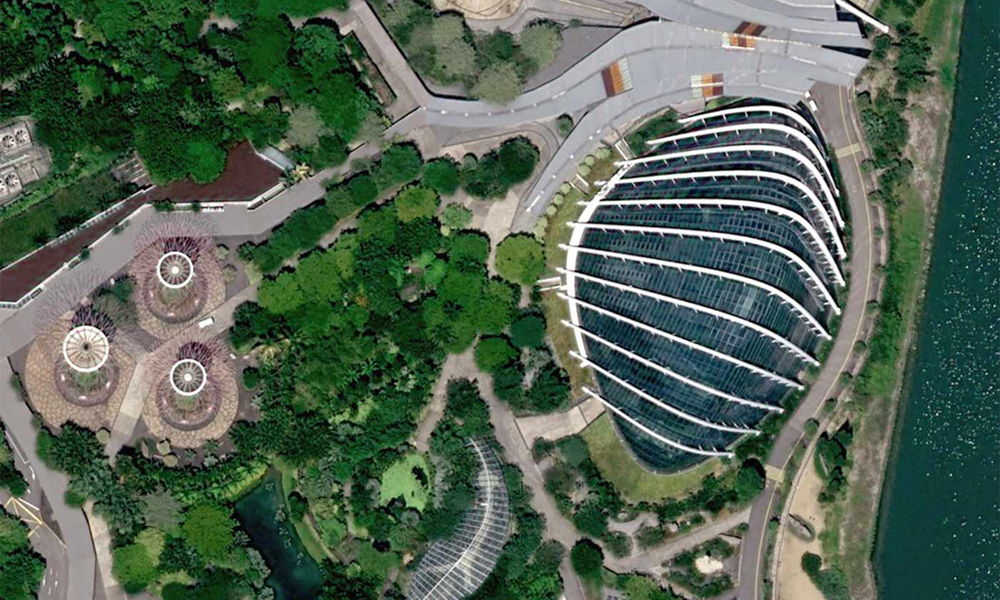
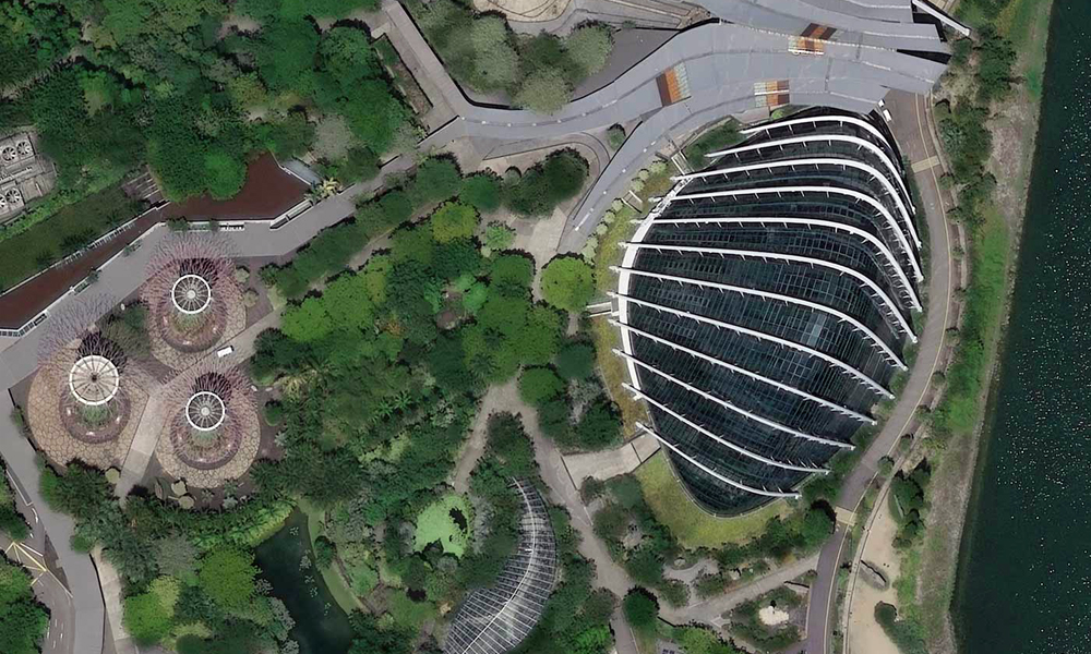
One major advancement is the availability of 15cm HD imagery, which provides remarkable resolution for monitoring applications ranging from urban planning to precision agriculture.
Below: Comparing the clarity of Pléiades Neo 15cm HD to 30cm over Singapore.
Furthermore, as satellite technology advances, increased satellite cadence and revisit rates are projected to become the new standard. This progress will enable rapid monitoring and response to dynamic events such as natural disasters or urban expansion, ultimately enhancing our ability to address these challenges.
The convergence of these advances marks the beginning of a new era in how we perceive, analyse, and respond to geographical data. It presents MaaS as a solution to address our planet's complex challenges, providing the tools and information needed to make informed decisions and build a more sustainable and resilient future.
The Geoimage Approach
Geoimage's MaaS solutions offer a comprehensive, data-driven approach to monitoring and tracking changes across diverse industries. By harnessing the capabilities of satellite imagery, we provide valuable insights to decision-makers in fields like mining and exploration, environmental oversight, and urban planning. Our core expertise is in change detection, enabling the early identification of crucial alterations, ensuring environmental compliance, enhancing safety, improving operational efficiency, and reducing costs for our clients. Here's a summary of our approach:
- Client consultation: We first start by comprehensively understanding your monitoring needs and objectives. During this initial phase, we engage in a discussion to determine your area of interest, use case, and the desired frequency of data updates.
- Data acquisition: Next, we source the required satellite imagery tailored to your specific requirements from our trusted partners.
- Data processing and integration: We meticulously process the acquired data, utilising techniques such as enhancement and georeferencing. This data undergoes a comprehensive analysis through advanced analytics and machine learning algorithms to extract valuable insights.
- Dashboard development and continuous monitoring: If necessary, we can seamlessly integrate the analysed data into your monitoring systems or we can create a customised dashboard for your convenience, ensuring easy access to the data. We also commit to ongoing monitoring of your area, based on your specified frequency, ensuring you always have access to the most current information.
- Reporting, support, and data management: As part of our services, we generate reports summarising key insights and provide continuous support for your team. Your monitoring data is securely stored and backed up on our servers, with a strong emphasis on compliance and data security. Our services are adaptable to scale with your evolving needs, and we consistently assess and enhance our performance to exceed your expectations.
Contact our expert team today to discover how our MaaS solutions can enhance your next project.