16 October, 2020
Discover how InSAR can improve Surface Movement Monitoring of critical infrastructure assets
InSAR technology operates by detecting and measuring changes in the Earth's surface velocity over time, with a remarkable level of precision ranging from millimetres to as high as 1-2mm, despite the satellite sensors being positioned more than 500km above the Earth's surface. Pertinent satellites pass over the targeted areas every 11 days, and it typically takes approximately 7-10 days to process the collected data and generate a comprehensive report.
While InSAR has been extensively employed in Europe, North America, and Asia for monitoring surface movements like landslides and the effects of infrastructure projects on urban environments, Australian asset managers are just beginning to explore the advantages of implementing this cutting-edge technology.
The numerous benefits of utilising InSAR for monitoring surface movements are as follows:
- Improved accountability: All stakeholders gain enhanced accountability by proactively monitoring large-scale infrastructure projects and adjacent assets for surface movement, both before, during, and after construction.
- Enhanced safety: With InSAR technology, there is no need for personnel to be physically present at the monitoring site, leading to improved safety outcomes.
- Cost reduction: InSAR enables the capture of substantial and valuable data sets more efficiently and effectively then traditional monitoring methods, resulting in reduced costs.
- Minimal infrastructure: InSAR eliminates the need for onsite infrastructure, thereby minimising requirements for training, maintenance, and repairs.
- High accuracy: InSAR consistently provides highly accurate results, with measurements accurate to several millimetres, ensuring reliable data for decision-making.
- Economical and efficient: Large areas can be captured in a single satellite overpass, making InSAR an economical and efficient solution for comprehensive surface movement monitoring.
- Improved data integrity and access: InSAR offers secure online access to a "single source of truth," enabling stakeholders to access reliable data from multiple devices anywhere with internet coverage.
- User-friendly communications: InSAR reports are designed to be easily understood by end users, eliminating the need for technical GIS/BIM skills or IT resources to interpret the findings.
- Excellent return on investment (ROI): In comparison to alternative and more traditional monitoring solutions, InSAR technology provides a favourable return on investment, making it a cost-effective choice for asset managers.
InSAR example - Cadia Mine, NSW
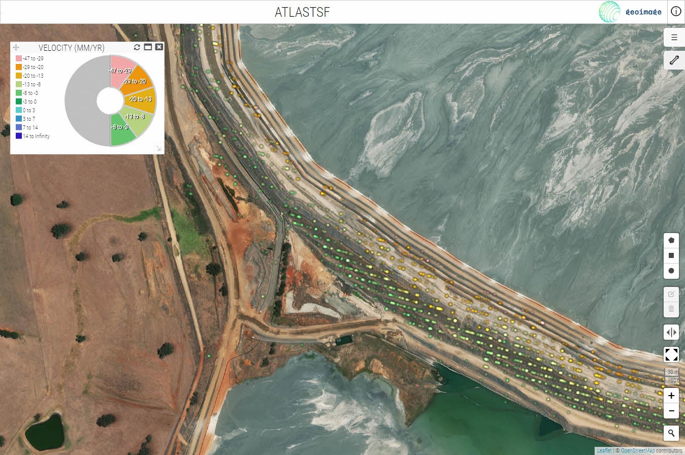
The images below showcase high-resolution satellite imagery overlaid with Geoimage’s InSAR data processing captured over the Cadia mine in January and February of 2018, a month before the breach of the tailings dam wall.
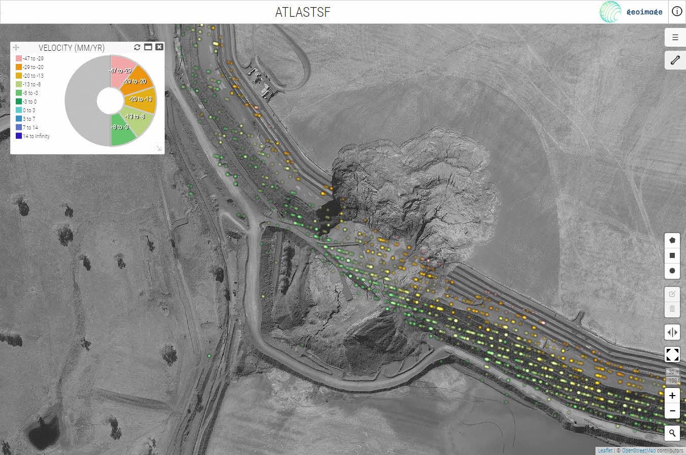
The InSAR data is colour-coded to show subsidence as red and uplift as blue with a spanning range of colours representing velocity in mm/year (the standard metric used for InSAR results). The display has been filtered to only show results where subsidence has occurred (orange through to green) and these points can be clearly observed along the top of the dam wall.
The After image shows the same InSAR data overlaid on a panchromatic (greyscale) image of the wall, post-failure.
Geoimage, with its expertise in geospatial solutions, is at the forefront of leveraging InSAR technology to optimise surface movement monitoring of critical infrastructure assets. By partnering with Geoimage, asset managers can harness the power of InSAR to enhance safety, reduce costs, improve accountability, and achieve highly accurate results, ultimately ensuring the integrity and longevity of their vital infrastructure projects.
To find out more about InSAR and how it can work for your business, email sales@geoimage.com.au. In addition, you can submit your enquiry through our website contact us tab or call us on 1300 143 350.

