01 December, 2023
What is the definition of satellite imagery resolution?
Satellite imagery has revolutionised our ability to observe and understand our planet. With technological advancements, we now have access to vast amounts of information captured by thousands of satellites orbiting Earth. One critical factor in satellite imaging is resolution, this determines the detail and clarity of the images. Resolution is primarily categorised into spectral and spatial resolution, each playing a vital role in satellite imaging.
Spatial resolution
Spatial resolution refers to the level of detail or the smallest feature that can be detected and represented in the image. It's the clarity or sharpness of the image based on the size of the smallest pixel on the ground.
In simpler terms, it's the ability of a satellite sensor to distinguish between objects or features on the Earth's surface. The higher the spatial resolution, the smaller the objects that can be seen in the image.
For instance, a satellite with high spatial resolution can capture fine details like individual buildings, cars, or trees. Meanwhile, a satellite with lower spatial resolution might only capture larger features like fields, rivers, or large buildings, as it cannot distinguish smaller objects due to larger pixel sizes.

Very High Resolution
Very high resolution (VHR), represented by satellites like Pléiades Neo and GeoEye-1, occupies the pinnacle of satellite image clarity. These state-of-the-art satellites utilise sophisticated sensors capable of capturing incredibly fine details, often as small as 15cm per pixel or even less depending on the nadir angle. These satellites are suitable for urban environments, where they offer precise insights into individual structures, roads, and even vehicles. This level of intricate detail proves indispensable for tasks like urban planning, infrastructure monitoring, and precision mapping.
High Resolution
High resolution (HR), exemplified by satellites like ALOS and SPOT 6/7, might not match the level of detail of VHR imagery, but it still delivers remarkable clarity, usually spanning from 50 centimetres to 2 metres per pixel. These satellites specialise in tasks such as environmental monitoring, agricultural assessments, and urban analysis. They offer clear visibility of significant features like buildings, rivers, and vegetation, crucially assisting in land use planning and detecting changes over time.
Medium Resolution
Medium resolution captures imagery at resolutions ranging from 2 to 30 metres per pixel. Although less detailed than VHR and HR imagery, medium resolution satellites are well-suited for regional mapping, land cover classification, and monitoring changes in larger environmental features like forests or coastlines. They strike a balance between detail and coverage, making them valuable for broad-scale analyses.
Low Resolution
Low resolution satellite imagery captures images with the least amount of detail, typically above 30 metres per pixel. These satellites offer a wide view of vast areas, making them suitable for global-scale observations, weather forecasting, and large-scale environmental studies. While lacking finer details, their broad coverage is essential for studying large-scale phenomena and weather patterns.
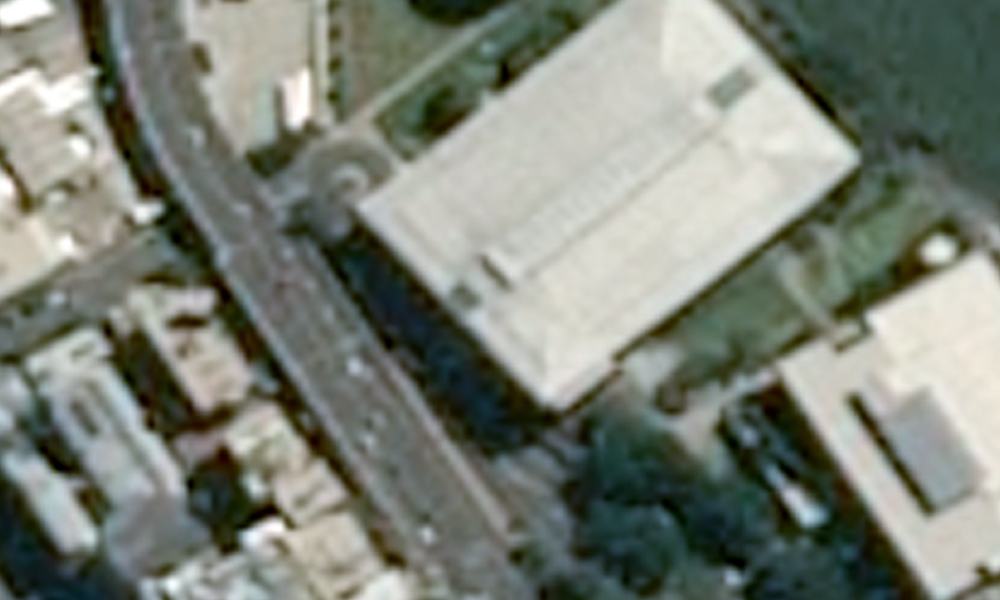
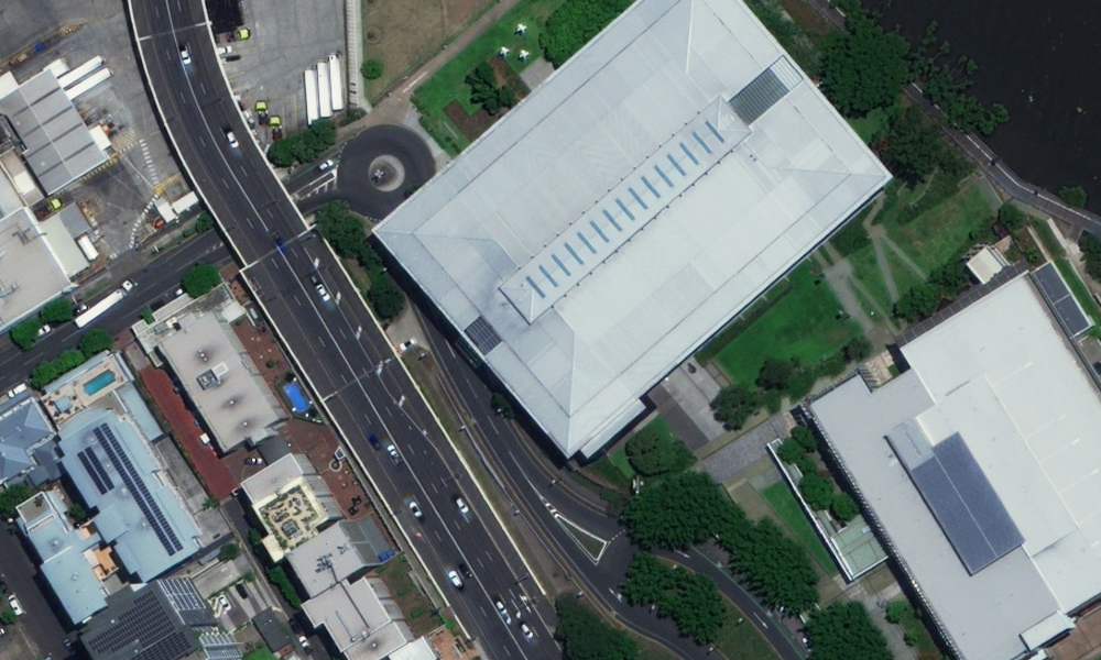
Above: Contrasting the resolution of 30cm with 1.5 metres over Brisbane, Australia.
Spectral resolution
Spectral resolution refers to the ability of a satellite sensor to distinguish between different wavelengths of electromagnetic radiation (usually light) that it detects. Different materials and objects reflect or emit light at varying wavelengths. A higher spectral resolution enables the sensor to capture more narrow and distinct bands of the electromagnetic spectrum, which in turn allows for more accurate discrimination of different features on the Earth's surface.
Many satellite sensors capture imagery in multiple spectral bands, including visible, near-infrared, shortwave infrared, and thermal infrared bands. This enables the analysis of vegetation health, land cover classification, soil moisture, and more. Certain satellites, like the ones made by our partner Pixxel, have hyperspectral sensors that capture hundreds of narrow, contiguous spectral bands, offering even finer detailed information.
Panchromatic
Panchromatic captures the entire visible spectrum as a single band, producing black-and-white images. Although it lacks colour differentiation, it offers high spatial resolution, providing detailed grayscale images useful in various applications.
RGB
RGB sensors capture data in three electromagnetic spectrum bands: Red, Green, and Blue. Each band corresponds to one of these primary colours, offering a basic colour representation but unable to distinguish beyond these three colours.
Multispectral
Multispectral sensors capture specific ranges of the electromagnetic spectrum across multiple bands, usually divided into distinct colours or wavelengths. They provide imagery in several bands, allowing differentiation between vegetation, water, urban areas, and more. This aids in land cover classification, environmental monitoring, and agricultural assessments.
Hyperspectral
Hyperspectral sensors capture a vast number of narrow and contiguous bands across the electromagnetic spectrum, offering a highly detailed and specific view of the reflected light. This enables precise identification and analysis of materials, vegetation types, and environmental conditions. Hyperspectral data is valuable in fields like mineral exploration, precision agriculture, and environmental research where fine spectral details are crucial.
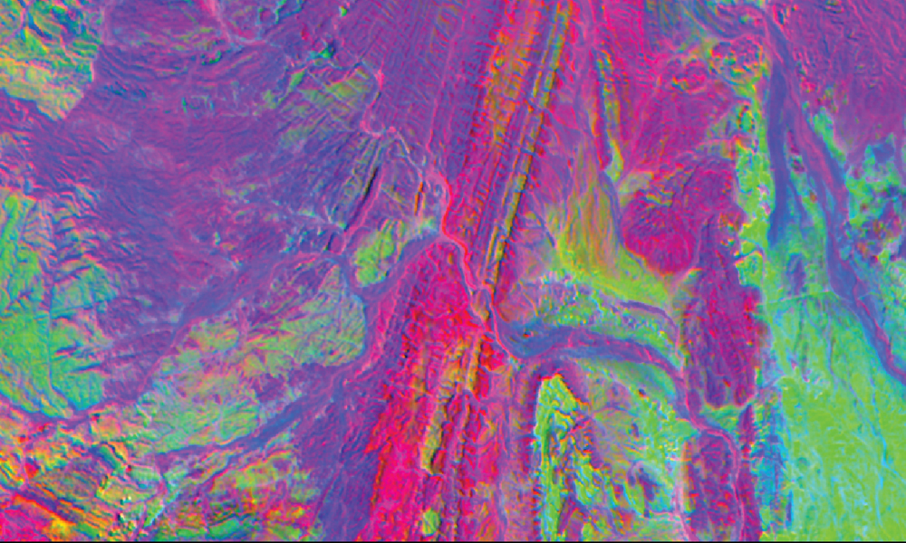
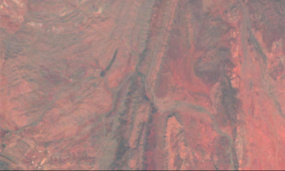
Above: Comparing a multispectral image to a hyperspectral one over a mining site in Australia.