27 February, 2023
Satellite imaging for flood mapping and monitoring: A powerful solution for disaster response and management
Natural disasters such as floods can cause significant damage to both urban and rural areas, leading to significant economic, environmental, and social impacts.
Flood mapping and monitoring are critical components of disaster management and can help prevent or minimise the damage caused by floods. Traditional methods of flood mapping and monitoring rely on ground-based sensors, which can be time-consuming, costly, and often ineffective, particularly in remote or inaccessible areas. However, the advancement of high-resolution satellite imagery and radar technology has significantly improved flood mapping and monitoring. This has resulted in increased accuracy and efficiency in predicting and assessing flood events, both before and after they occur, providing significant benefits to disaster management.
High-resolution optical and radar imagery can help map and monitor floods with high accuracy and speed, providing valuable information to decision-makers, emergency response teams, and other stakeholders. Here are some of the benefits of satellite imagery for flood mapping and monitoring:
Timely and accurate information
Decision-makers can act quickly and effectively by using high-resolution satellite imagery to determine the extent and severity of flooding quickly and accurately. Furthermore, planning and preparation for upcoming floods can be facilitated by using this data to identify vulnerable areas and create maps of flood hazards. The extent of the flood, infrastructure damage, and affected features such as buildings and vegetation can all be precisely identified using very-high-resolution satellite imagery with resolutions of up to 30cm or 15cm.
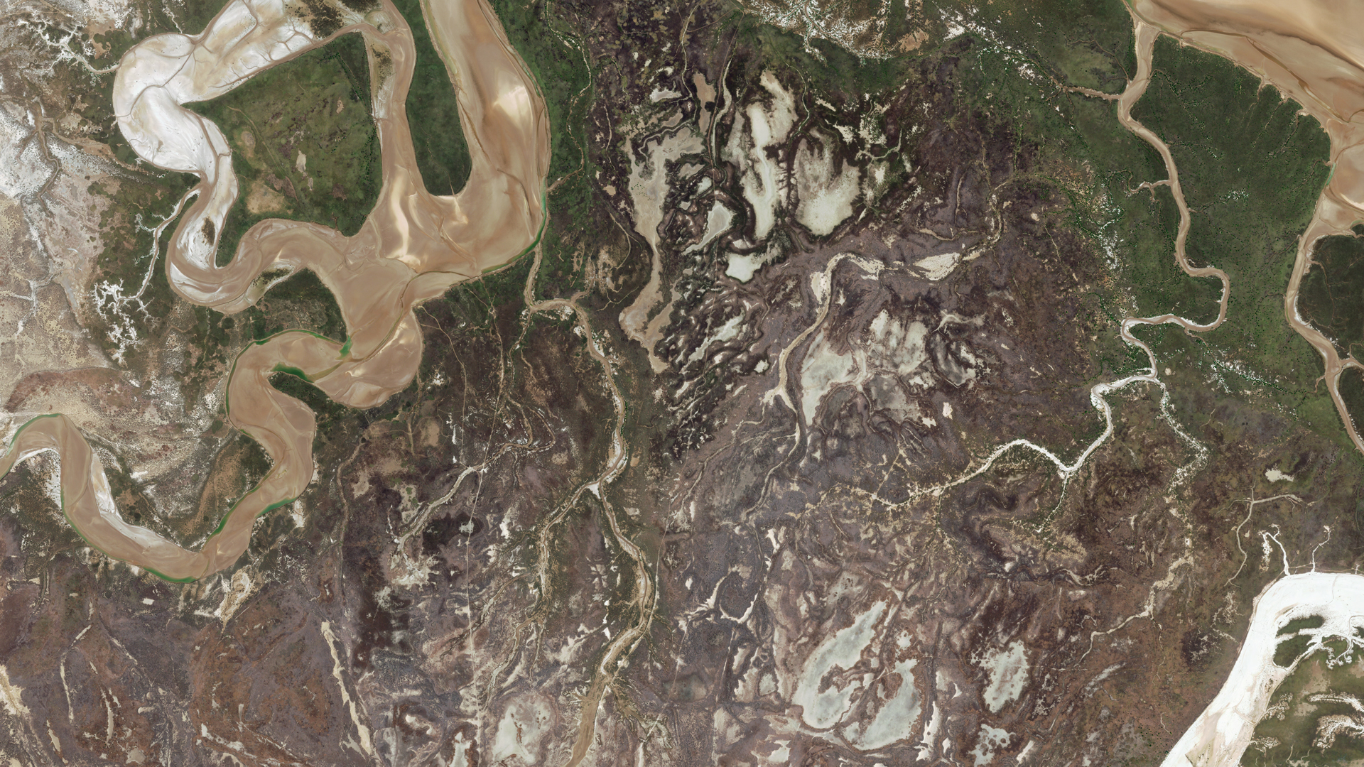
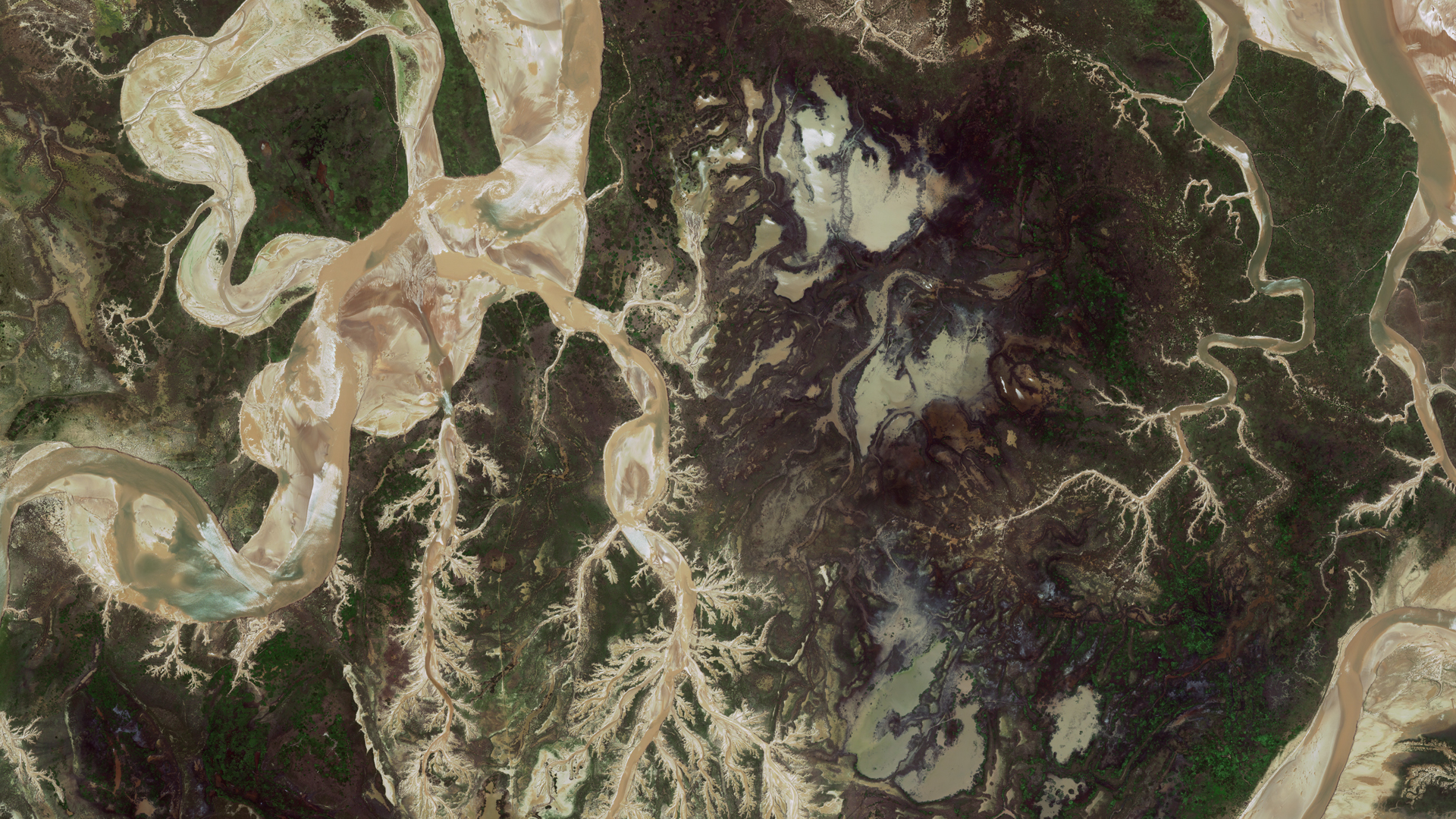
Below: A sample comparison of significant flooding of the Fitzroy River, south of Derby Western Australia. The first capture was taken 19 November, 2022 using WorldView-2 and the second capture was taken on 25 January, 2023 using WorldView-3.
Cost-effective
In comparison to conventional techniques, which call for the installation and upkeep of ground-based sensors, using high-resolution satellite imagery and radar for flood mapping and monitoring is cost-effective. Additionally, satellite-based imagery can cover large areas quickly and at a relatively low cost.
Accessibility
Satellite imagery can provide information on flooded areas that may be difficult or impossible to reach by ground-based sensors. This is particularly important for monitoring floods in remote or inaccessible regions, where timely information can be crucial in preventing loss of life and damage to property.
Coverage
Continuous coverage can be provided by most satellite providers, allowing for the monitoring of floods over time. This can aid in the forecasting of flood patterns, the detection of trends, and the development of early warning systems.
All weather capability
In contrast to optical imagery, radar can penetrate clouds and capture images in all weather conditions. This is particularly important in areas prone to flooding, where clouds and rain can obstruct the view of optical satellites. With satellite radar imaging, decision-makers can obtain a more comprehensive view of the situation, even in adverse weather conditions.
Integration
A more complete understanding of flooding situations can be provided by combining high-resolution satellite imagery and radar with other technologies like geographic information systems (GIS) and artificial intelligence (AI). Through integration, flood models and simulations can be created, which can help with planning and decision-making.
As a leading provider of geospatial and satellite imagery services, Geoimage can provide a range of resources and tools to assist with flood mapping and monitoring. By partnering with prominent satellite imagery providers like Maxar, Airbus, and RESTEC, we can offer the most advanced technology and software solutions commercially available. Contact us today to learn how we can help you with your management and monitoring requirements.