05 March, 2024
Lineament interpretation using satellite imagery for informed decision-making
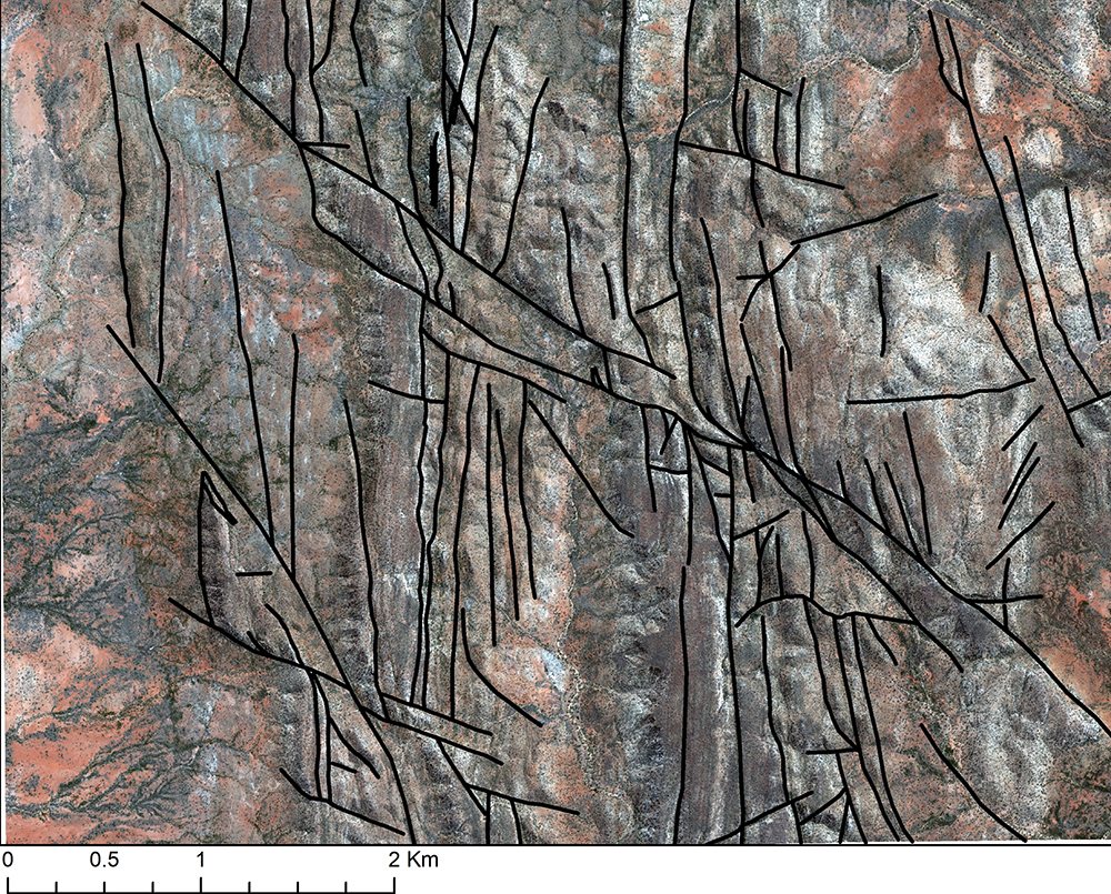
Lineament interpretation using satellite imagery is a process of identifying and analysing linear or linear-like features that are visible in satellite images. These features can include faults, fractures, geological boundaries, and other linear structures that may have significance in geological or environmental studies.
The purpose of lineament interpretation is to detect, map, and define these linear features to gain a better understanding of the geological, environmental, or engineering aspects of a particular area. This information can be valuable in various applications, such as mineral exploration, oil and gas exploration, and environmental impact assessments.
Applications of lineament interpretation
Below are a few examples of how lineament interpretation using satellite data can be applied across various industries to support decision-making, planning, and research efforts.
Mineral exploration: By detecting fault zones and fractures, lineament interpretation aids in pinpointing potential mineral deposits.
Oil and gas exploration: Lineament interpretation can be used to identify potential hydrocarbon traps and migration pathways. Faults and fractures can influence the accumulation and movement of oil and gas.
Land use planning: Identifying areas suitable for urban development, agriculture, and conservation supports effective land use planning.
Erosion and land degradation: Monitoring erosion-prone areas allows for timely interventions to prevent land degradation.
Construction site selection: Identifying suitable sites for construction projects based on geological stability. Railway planning: Determining optimal routes for railways.
Hydroelectric power planning: Identifying suitable sites for hydroelectric power generation contributes to sustainable energy production.
Disaster response planning: After natural disasters, such as bushfires or floods, lineament interpretation can help assess damage and plan effective disaster response strategies.
Benefits of lineament interpretation
Incorporating lineament interpretation with satellite data offers numerous benefits for various industries:
Risk mitigation: It can help identify areas prone to natural disasters, aiding in risk assessment and disaster management. This knowledge is invaluable for minimising damage and loss.
Continuous monitoring: Lineament interpretation enables ongoing monitoring of changing landscapes. This is essential for forestry, mining, and urban planning, as it helps in adapting strategies to evolving conditions.
Cost-efficiency: By providing preliminary data, lineament interpretation reduces the need for extensive field surveys. This saves both time and resources, making projects more cost-effective.
Geological understanding: Lineament interpretation provides valuable insights into the geological features and structures of an area. It helps geologists and researchers understand the tectonic history and structural characteristics of a region.
Want to know more?
Whether you have questions, need advice, or want to discuss lineament interpretation, Geoimage is here to support you. We offer expertise in lineament interpretation through advanced satellite imagery analysis and data processing techniques. With our assistance, you can take advantage of lineament interpretation to make informed decisions, mitigate risks, and optimise resource utilisation.